You are here: Home > Heritage > Digital maps
Heritage
Home
Explore thousands of images and more with Canterbury Stories
Discover your family’s history at our libraries
Click on Thumbnail to view enlargement ~ Title index ~ Printing Tips
Previous Page ~ Next Page

 Discover your family’s history at our libraries
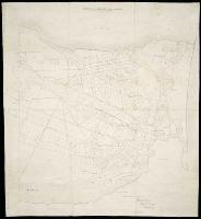 Mandeville & Rangiora Road District
![Image of [Maori reserve north of Kaiapoi]](ATL-Acc-39.jpg) [Maori reserve north of Kaiapoi]
[Maori reserve north of Kaiapoi]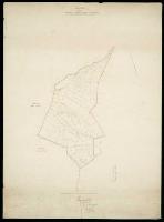 Riccarton : formerly Central Avon Road District
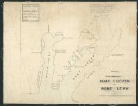 Sketch of the harbours of Port Cooper and Port Levy
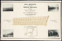 New Brighton, Christchurch, building allotments
![Image of [The central portion of the Southern Alps of New Zealand]](ATL-Acc-4849.jpg) [The central portion of the Southern Alps of New Zealand]
[The central portion of the Southern Alps of New Zealand]![Image of [Map of St Leonard's run, Amuri County]](ATL-Acc-501.jpg) [Map of St Leonard's run, Amuri County]
[Map of St Leonard's run, Amuri County]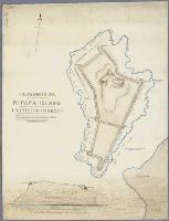 Taununu's pa, Ripapa Island, Lyttelton Harbour
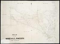 Map of the Mandeville and Rangiora Road District
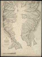 Akaroa Harbour
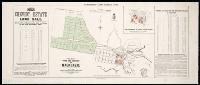 Canterbury Land District. No. 73 : plan of the town and suburbs of Mackenzie.
![Image of [Composite map of following SD's] : [79 Leeston, 1890: 80 Halswell, 1893: 94 Southbridge, 1897 & 95 Ellesmere, 1899].](ATL-Acc-6608.jpg) [Composite map of following SD's] : [79 Leeston, 1890: 80 Halswell, 1893: 94 Southbridge, 1897 & 95 Ellesmere, 1899].
[Composite map of following SD's] : [79 Leeston, 1890: 80 Halswell, 1893: 94 Southbridge, 1897 & 95 Ellesmere, 1899].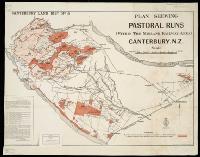 Canterbury Land District. No. 8 : pastoral runs within the Midland Railway area
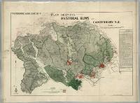 Canterbury Land District. No. 6
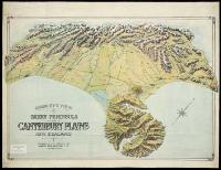 Bird's eye view of Banks Peninsula and Canterbury Plains